


Backpacking NorCal/Oregon Part 5 | The Lost Coast
- Taylor McNelis
- May 4, 2020
- 7 min read
Rise and shine in the great state of California - we had a really busy day full of wild adventures! This will be a good one.

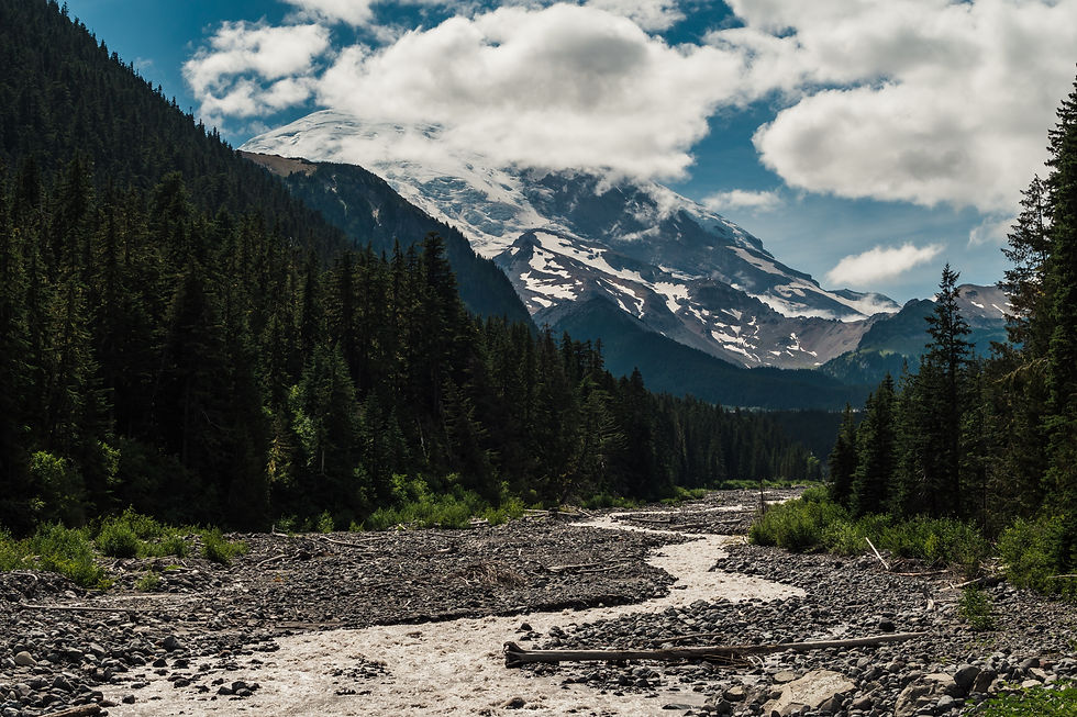
After spending a night under the Redwoods, we got up before the sun to go on another hike through the Redwood Forest. The hike was going to be pretty easy, short, and supposed to bring you to the top of a cliff where you’re looking down on top of the Redwoods and the Pacific Ocean! But the theme of this trip if you remember, was nothing goes according to plan and that’s what happened.
The hike we took ended up being pretty long and moderately difficult. Nothing we hadn’t done before but not what we mentally prepared for either. It also didn’t bring us to the top of the trees. I’m not sure where we went wrong but the entire hike was downhill...meaning coming back was a pain in the ass.

But anyways, the hike itself was really cool and even though the view wasn’t what we wanted, it was still a cool experience and I’m glad we did it. Multiple times we contemplated on just turning around but we decided, hey, we’ve gone this far we might as well see where it takes us.

We crossed a somewhat sketchy wooden bridge covered in moss, and even crossed a broken bridge we probably weren’t supposed to. But hey, we were so close to the bottom we weren’t turning around over something this small. We’re getting to the end of this trail haha.
The view at the bottom was awesome; there’s something different about walking through larger than life trees only to have it spit you out by the Pacific Ocean.


The hike back was rough. I won’t lie. Anyone in our group who says they didn’t think it was hard is lying. It was all up hill for maybe 4 miles? I think it was 8 miles in total? I’m not sure exactly. In reality it wasn’t hard; we just weren’t ready for it. But I counted somewhere around 20 switchbacks I think?
Anyways we made it back to the top and the next move was to find some grub because we were starving.

We found Log Cabin Diner on google maps which is right off Highway 101 in Klamath, CA and had the 2nd best meal of the trip. I can’t say enough great things about this place; if I could give it a 6/5 stars I would. It was phenomenal. Not only was the food incredible but everyone who worked there was very friendly and hospitable. I would make a detour on a trip to eat here if I was in the area.

We all pigged out on what looks like a giant breakfast buffet but really just our individual meals...maybe that’s why they liked us so much. But seriously, they even have a diner dog. A black lab who lies around and greets you at the front door. I had gone out to the car to grab my phone and camera charger, and on my way back in this older couple and a black lab were walking in. So I held the door open for them and they walked in without the dog so I said, “excuse me is this your dog?” and the older lady said “no he’s the diner dog.” That’s awesome.

Log Cabin Diner had the charm of an old southern country restaurant with above and beyond service and classic country breakfast.
After our much needed pig out session we headed on the road to Fern Canyon, which is located in Orik, California. Not too far of a drive and Highway 101 is very scenic in some areas.

Fern Canyon was really cool to check out and more of a walk than a hike. I think it was harder for the minivan driving there than the actual hike itself. Fern Canyon is very unique and very pretty; easy for any age as well. My only tip is to bring water shoes or sandals because your feet will get wet. Sure you can do what we did, and find ways to navigate through the canyon where the creek doesn’t flow through as high and balance yourself on logs and rocks. But eventually you’re going to get wet. This was a very cool leisure stroll, a little bit of optional climbing over trees and rocks if you wish, but all in all this was a cool pit stop to walk around and stretch our legs a bit.


After Fern Canyon we continued south to Ferndale CA and the Lost Coast Trail on Mattole Beach.
My second favorite part of the entire trip. Hold on, let me back up a second, I forgot about this part.
To get here, we had to drive through Eureka, California. And I apologize in advance if you’re from Eureka; not because of what I’m about to say but because you actually have to live there. Eureka looks like the city version of the back country Motel 6 public bathroom. It is one dirty looking place with nothing nice to look at. I thought maybe because it was a really foggy and dreary day, but a closer look tells you all you need to know about Eureka - you don’t want to live there. And you know what, I could be wrong. Maybe we drove down every bad street there was in Eureka and saw all the wrong things at the right time. But I have zero desire to go ever go back or drive through unless I’m showing someone what I saw. On the bright side, after three or four stops we finally found a cigar shop that actually sold cigars and wasn’t just a weed shop or "closed for good". We all bought cigars for later that night camping. Def worth the stop for that.
Anyways, back to the Lost Coast.

I’m not sure where to even begin. This was so cool I made a Facebook Live video of our arrival and posted it when we eventually got service. The Lost Coast is planted in the middle of nowhere between Petrolia and Ferndale. To give you an even better idea of what we’re talking about here: there is 1 road in and 1 road out...about 70 miles of steep, winding, rocky, pot hole ridden asphalt. You ever driven in Colorado Springs before? It's like that. If you’re talented enough as a construction crew to drive your equipment into Petrolia and build a house you deserve a six figure salary because the drive alone in anything larger than an SUV/Pickup is borderline disastrous. The nearest town is Petrolia, which has a population of I would guess 50 people but according to Wikipedia it’s actually 200. I’m not sure where they are though because there is nothing there...not even a gas station or any store at all in fact.
This place is wild, and I mean that in two senses: it’s wild as in the dictionary term of being uninhabitable, not domesticated, uncultivated; and it’s also wild as in the slang use for exciting and special/unusual.

We made our windy descent down the road; it was so foggy at times you couldn’t see 30 ft in front of you and at best your vision was 50 yards...at best. I honestly felt like I was driving through mountain ranges in Ireland; rocky, green cliff sides and cows roaming free everywhere. Then as we come around this turn on the edge of one of the mountains, the fog clears and we see this beautiful valley below leading to the Pacific ocean.

I couldn’t believe what I was looking at - we were awestruck at the sight of a golden beach resting next to luscious green mountains; it didn’t make sense. We pulled over on the side of the road and took some pictures looking out at the ocean before continuing our way down. I took something like 100 pictures here and we stopped multiple times along the way to take more photos of the mountains. Untamed wilderness with not a single person for miles, nothing around you for miles and miles but mountains and the ocean. I place this right up there with Shasta Trinity as the most beautiful views I have ever experienced.


We set up camp on the beach and tried our best to stay warm on an extremely windy day, colder than usual for this area as the temperature in the summer time supposedly sits around 70-80 degrees. We took it easy and threw the football around a bit and dragged some huge logs and rocks near our campfire so we could have a place to sit later that night.


A nice dinner by the ocean as the sun was setting sounded ideal but it was so windy we couldn’t enjoy the view over there. Luckily, the ridges of sand blocked our tent from most of the wind so it really wasn’t bad once we left the backed away from the water.

We drank whiskey and had cigars and I even captured my favorite photo of the entire trip - Charlie lounging in the sand, smoking a cigar with a bottle of Jim Bean.


Tristan and Ian had the brilliant idea of doing astrophotography since we had a perfectly clear view of the night sky. I decided to join them and take my first attempt at night photography. I’ve never seen so many stars in my life; my aunt lives out in the country and I’ve gone camping plenty of times but the stars were never this clear.

I’m really happy with how these turned out and I think I found my new hobby.

That was about it for this day, we packed a lot into a short period and I would 1000% come back and hike the Lost Coast some day and spend more time out here.
Until next time guys. In the morning we make our way to Point Reyes and Bolinas for one last hike and camping.


Comments